Birding 101: Figuring out where to bird (using eBird)
Are you thinking of going out to bird, but aren’t sure where to go? Is there a specific species you’re interested in finding but unsure if it’s being seen near you right now?
Ebird has a capability called Target Species that is just what you need.

What I normally do is give it my local county (or whatever location I’m planning to bird), and set it to show me birds that are not currently on my year or life list to show me what birds I haven’t seen yet that might make interesting targets. Click on Show target species, and it’ll bring up customized for you. This does require that you have an eBird account and be logged into the site, but the account is free, and as you get more interested in birding, you’ll find this is a critical resource to have and contribute to, so if you haven’t signed up, this is a good reason why you should.

The birds are sorted based on, effectively, how easy they will be to find, based on how often they are being seen by others in the given time period (in this case, the first half of September — if you do this in the first week of a month, I suggest you do a custom date range for the previous month since there will be limited data.
I will note — because I know I’ll get asked — that California Quail continues to be a nemisis species for me here in the county. I have no idea why, but I believe at one point I got put on the boycott list by the Quail guild, and every bird in the county is on orders to hide when they see me coming. Quail in general, though, also seem to becoming harder to find in the county, but I don’t believe we’re really considered reasons why (other than the obvious: habitat loss). Maybe we should put this drop in population I think I’m seeing on our radar for closer examination.
And not seeing a Eurasian Collared-Dove yet? As they’ve continued to invade the county, that seems like an interesting lapse.
But Western Tanager? That would be a fun bird to find, so let’s see where they’re being seen. Click on the map for Western Tanager.

As you can see, there are lots of sightings. Blue sightings are historical, red marks are recent. To make it easier to see where they’re being seen now, Click on the Date and set the date range to Current Year.
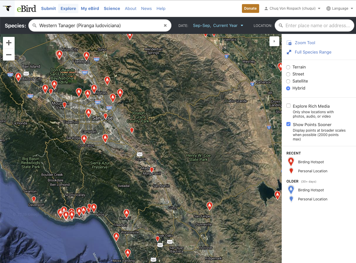
Now the map only shows sightings from this year. You can now zoom in and start evaluating specific locations to see which one you want to visit to try to find this species.

Clicking on various sighting, I find this one, where a bunch of different birders have been finding multiple numbers of the bird over the last ten days. It’s also an area that’s close to me — and which I happened to write the Birding guide for Santa Clara County Audubon, and while this is one location in the county with good birding more or less year round, in fall migration, which is kicking in for warblers, it can be awesome. So this is a good candidate for me to find the bird, and coincidentally, another bird on my target list, the California Thrasher, happens to be there.
So guess where I’m visiting sometime this week?
This is a really useful tool to help you understand what’s going in a regional now, to help you find what’s most interesting to you and where it’s being seen. If you’re headed to a new location and don’t know where to bird, it’s a nice research tool for getting to know the better birding locations where you’ll be at the time you’ll be going.
If you haven’t tried it yet, check it out and see what it tells you about what’s happening around you.